2012 - MTB in Alpes de Haute Provence
September 21 - 30, 2012
 |
| Overall itinerary |
This year Mike and Thom being in
New Zealand could not participate in our annual trip, and having failed to
convince my friends from the Massa Martana MTB group to join me (they all work
and have young children in school) I decided to go alone.
I decided to go to Alpes de Haute
Provence in late September to get some decent weather.
Itinerary
Among the many MTB routes
described by VTopo I selected the following:
- "les chemins du
soleil" from Grenoble to Nice,
- "la Transverdon" from
Col d'Allos to Manosque,
- "Alpes-Provence" from
Col de Larche ending also Manosque.
I combined these three routes
into a loop circuit in the Alpes de Haute Provence. :
a) - starting in Castellane and
along the gorges of Verdon via Rougon, La Palud sur Verdon, Esparron and
Gréoux-les-Bains to reach Manosque.
b) - from Manosque via St
Michel-l'observatoire and St Etienne-les-Orgues to climb the mountain of Lure
and down the ridge trail to Peipin.
c) - from Peipin to
Digne-les-Bains across the "terres noires" via les Dourbes, Tartonne,
Thorame-basse, St André-les-Alpes and back to Castellane.
Cartography
The VTopo guides mentioned above
include copies of IGN detailed maps at 1/50, 000, route description and
indicate places of interest on, or near the route. To minimize weight I take
along only the pages relevant to my itinerary. However only 1/25,000 maps are precise enough on these type
of MB trips, but they are heavy.
My solution:
"Openrunner"
(www.openrunner.com) is a site that lets you draw your route and gives you
distance and altitude gains, using IGN maps.
I trace my route on openrunner
and do a "screen save" as soon as my route leaves the screen and save
it as a JPEG file. I continue
drawing my route for the day and I save the file, which is then
"interpreted" by openrunner to show me the course of the day in terms
of distance and altitude gain. I
save this file as a JPEG.
Then I transfer these JPEG images
to "dropbox", arranges them in the order of the route and the load on
my Iphone.
Advantage: less weight and I
don't have to purchase IGN maps (approx 10 € a map!).
Disadvantages: files on Iphone
are not as sharp as paper maps, I need to carry along the Iphone charger, and
in case of problems with Iphone I am without maps, however for this trip the
route was so well marked in the field that I could have continued without maps.
Material and equipment
With my new full suspension bike
the only possible luggage are a handlebar bag (to put maps, documents and some
emergency rations) and a small bag under the seat to put repair equipment
(spare tube, patches, glue, tools, etc.), everything else should go in a
backpack.
After a ruthless selection I
managed to reduce the weight of the backpack to 4, 5 kg. Under these conditions
elegance and fancy aftershave will stay behind!
For future information I take:
Backpack (780 gr.):
1 long pants (320 gr)
1 long sleeve shirt (213 gr)
2 underwear (170 gr)
2 pairs of socks (137 gr)
1 T-shirt to sleep (206 gr)
1 short sleeve shirt synthetic
fabric (143 gr)
2 synthetic long sleeved shirts
(380 gr)
1 biking jacket gore-wind
mid-season (462 gr)
1 rain pants (209 gr)
1 rain jacket (310 gr)
overshoes (106 gr)
toilet kit (207 gr)
charger for Iphone (91 gr)
documents, money, credit card,
paper and pencil (240 gr)
3 maps (312 gr)
selected pages of guides (164 gr)
flashlight (51 gr)
warm hat and gloves (150 gr)
all wrapped in plastic bags to
ensure waterproofing
Total (backpack included): 4515 gr
handlebar bag (650 g)
Iphone (150 gr)
route maps for the day
knife (48 gr)
glasses (100 gr)
emergency food (150 gr)
Total (bag included): 1098 gr
seatbag (165 gr):
spare tube, patches, tire levers
and glue (162 gr)
multi-tool (160 gr)
chain oil, brush and cloth (50
gr)
derailleur hanger (16 gr)
lock (263 gr)
1 set of pads for disc brakes (31
gr)
Total (bag included): 847 gr
on the bike:
2 water canteens (total capacity
1.25 L)
air pump (181 gr)
At 4,5 kg the weight of the
backpack was not a problem and I could enjoy riding the trails, in any case I
cannot see how to lower the weight any further!
The trip
Originally the trip was planned
for late August but because of lack of accommodations in the refuges I
rescheduled it for the end of September. In spite of this I still could not get
accommodation for the first day before Moustiers-Ste-Marie a first day ride of
60 km and 1900 meters of elevation gain!
September 22: Castellane to
Moustiers-Ste-Marie (60 km, D+ 1900 m)
After a night at the gite
"Oustaou" in Castellane (tel. 04 9283 7727), Christian manager of the
gite, agrees to keep me company on his MTB as far as Rougon. The first
kilometers are always slow since one has to get used to riding with a backpack,
to find the right rhythm and to warm up the muscles. It is cool but as the sun comes up and as we pedal harder
and harder we quickly take off jackets and gloves.
Nice track sometime a bit (or
very!) rocky in places and we reach the plateau de Suech at 1200 m.
Rougon above the Gorges du Verdon
is also known for its vulture’s nests in the walls of the gorge, but they must
be sleeping since I could not see a singe one.
I continue alone to "les
Chauvets" and after a nice downhill to La Palud-sur-Verdon I have a quite
good lamb "tajine" for lunch.
The trail climbs (I push the bike) to Chateauneuf-les-Moustiers and
continues on the north side of the ridge Montdenier on a pleasant old Roman
road to a place called "les Bondils."
My full suspension bike is much
more comfortable and efficient than the old semi-rigid, and much lighter to
carry. The backpack is also much more convenient than rear panniers.
The climb to the top of the
"pavillon" (elev. 1625 m) is hard with a lot of walking/pushing and
frequent stops to rest, but the view from the top is well worth the effort. The
descent is on a very technical single track, very rocky and tricky to ride, I do
most of it on foot and very slowly. The end of the descent to Moustiers is
easier but not before going up another very steep hill impossible to do on a
bike.
I found the hotel easily; thirty
Quebecois bikers visiting the area on bikes occupy it.
No problem sleeping after this
rough first day, I just hope tomorrow will be easier.
September 23: Moustiers to St
Martin-de-Brome (72 km, D+ 1216 m)
The track is nice to Lake Ste
Croix, and then becomes a very difficult climb to reach the "plateau de
Valensole", I did push the bike all the way up and arriving on the plateau
was quite a relief.
 | |
| Nice trail after Moustiers |
 |
| Lac Ste Croix |
 |
| Beginning of the climb to plateau de Valensole |
 |
| Hard track, all uphill. |
 | |
| Plateau de Valensole |
 |
| Lavender fields (smells good too!) |
After Montpezat, a pretty
village, there is a great downhill trail following "ravin de St.
Pierre" which ends up by a small lake, where I had a quick picnic. My
"real" lunch was in Quinson where I had a huge "salade de
crudités" with a beer.
The gite du Payanet is 2-3 kms
before St. Martin-de-Brome: it is out in the woods, I have the second floor all
to myself, while downstairs is a group of delinquent youngsters being "reinserted"
in society. The "coaches" have a tough job that they are doing with
conviction and consideration under difficult circumstances, they have to be
admired. The home cooked "civet de lièvre" served for dinner was
delicious with a glass of local rosé wine.
September 24: St Martin-de Brome
to St Michel-l'observatoire (44 km, D+ 1302 m)
Overcast skies and rainy
forecast, a good opportunity to try my new lightweight, ultra waterproof and
breathable rain jacket! First drops while passing through Gréoux-les-Bains, a
spa town without much interest, followed by a real rain storm where I quickly
put on jacket, pants and overshoes rain: I stay perfectly dry, jacket was a
great purchase!
Down to Manosque I met a lone
young hiker who left Royan and heading to Grasse. We talk while our clothes
dry.
Getting out of Manosque I follow
in reverse the route "Alpes-Provence". No difficulty since I have the
IGN maps, but it would have been easier if the track had been marked in both
directions. I should say here that the routes are very well marked and it would
be possible to follow them without any maps (not that I suggest it!)
At Dauphin I met a biker who
offered to accompany me to St Michel-l'observatoire on small paths known only
to himself. Pleasant ride where I just follow without any concern for
directions to the hotel de l'observatoire (tel. 04 9276 5227) in St Michel. My
room had a great view of the surrounding countryside.
 |
| Room with a view (and sunshine!) |
Day of rest before climbing the
mountain of Lure tomorrow.
September 25: St
Michel-l'observatoire to Peipin (66 km, D+ 1820 m)
Speaking with the owner of the
hotel who informed me that the weather was supposed to worsen in the next few
days, I decided to climb mountain de Lure to day. To save time I decided to
take the asphalt road to St-Etienne-les-Orgues.
The route was without interest
via Revest-des-Brousses and Ongles until St Etienne-les-Orgues: the climb to
the top of Lure was slow and monotonous interrupted only by several showers
(thanks again to my waterproof jacket.
 |
| Great house near Revest-des-Brousses |
Since there are markers for distance and altitude on the road I checked
my meter and realized that it was 3-4% optimistic on distance. At the summit, candidates to an
outdoors school were fighting fog, cold (10°C) and violent wind while going
through various outdoors exercises.
For information for future trips there is a gite a little below the top
of Lure (tel. 04 9273 1914 to be checked) but it looked closed during my visit.


The strong wind cleared the fog
at "pas de la graille" and I started a nice descent on the crest
trail going all the way down to Peipin where I find a place at the gite
"la Feiniere" (tel. 04 9262 4402).
The descent was the high point
(so to speak!) of the day, not too technical, beautiful scenery and all
downhill.
 |
| Looking back on "pas de la Graille" |
 |
| Windy and stormy day on top of Lure. |
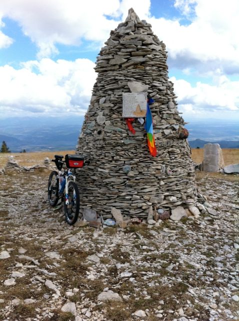 |
| Cairn 2000 |
 |
| Jacques in front of Cairn 2000 |
 |
| Great vistas from the top of Lure |
September 26: Peipin to
Mallemoisson (36 km, D+ 900 m)
From Peipin I join the"
chemins du soleil" track that I shall follow as far as Castellane, it is
also very well marked and to-day will be an easy day of few kilometers and my
first foray in the "terres noires" a soil made of broken slate
material.
This morning to lighten my
backpack I decide to send home maps and guides no longer needed. The Peipin
post office is closed on Wednesday, the one in Aubignosc does not open before
09:00, while in Château-Arnoux it closes at 11:30, and there is no office in
l'Escale! When are those postmen working, if ever!
The first trail in the
"terres noires" is interesting, they are sedimentary rocks resembling
black crushed slate on which some vegetation grows, making for a nice contrast
between the green of the vegetation and the dark black of the soil. Interesting and fun for mountain biking,
good traction and fun to ride.
 |
| Colours, colours, colours! |
 |
| And more! |
After l' Escale an easy climb
through "foret des pénitents" and down to Mirabeau and Mallemoisson.
 |
| Picnic (with Lindt chocolate) |
Hotel Mirabeau is a "non hotel" no charm, close to the road, and at
dinner about a dozen persons each sitting alone at a table, not a very exciting
evening! In any case I go to bed
early to get ready for an early start tomorrow.
September 27: Mallemoisson to la
Clappe (42 km, D+ 1550 m)
I recognize the route we had
taken during our ride in this area in 2010 with Mike, Thom and Georg. Nice to
be in familiar territory!
Follows a difficult climb
on a narrow and sometimes steep track to "hautes baties de Cousson"
ruins where I eat my picnic next a fountain.
 |
| Rocky trails |
 |
| More rocks! |
A regular and long climb to "pas Entrages"(elev.
1213 m). There I meet a Swiss hiker with whom I share some chocolate since
today is his birthday. He is also
heading to gite de la Clappe for the evening. He will be the last hiker I meet during the full trip,
except for the MTBer I met after Manosque I did not see a single other person on
the trail.
This is "terres noires"
territory, a paradise for MTBers but I have to keep careful and no take too
many risks, a bad fall could spell disaster since I am alone. Nevertheless, the
scenery is beautiful, weather is good and it is all downhill to gite de la
Clappe (tel. 04 9235 3693).
 |
| Trail through terres noires |
 |
| Terres noires |
 |
| And again! |
 |
| On the way to gite de la Clappe. |
Very nice owners, a room to
myself, a good dinner with birthday cake for the Swiss hiker, a welcome change
from the previous evening, what more could I ask for?
September 28: la Clappe to
Tartonne (36 km, D+ 1280)
Fun ride through pine forest to
Vaumet, where they are digging a trench in the middle of the road to install a
water pipe. The dirt they have
excavated is soft and not ideal for riding a bicycle, whether an MTB or
not! Fortunately after 3 km the
work ends and I am back on a decent road.
 |
| Better not put your wheels in the trench. |
A few seconds of inattention and
I fall off fortunately without any injuries to bike or riders. And then a few meters further I have my
first flat. I fix it on the road
and am glad to see the new double action pump works very well.
The climb to "col de
Cine" is long and monotonous but not really difficult and I enjoy the sun
and the scenery.
 |
| Les terres noires |
 |
| Trail through les terres noires |
 |
| Nice patterns |
 |
| Again. |
 |
| Last one! |
The descent to "clue de la
Peine" on the other hand is steep, technical and dangerous with
landslides, and I end up doing quite a bit of walking, which no as bad as it
sounds since it stretches the muscles and eliminates cramps.
The "clue de la Peine" is
a tunnel a few meters long, dug by hand at the end of the 19th century, the
site is impressive: a narrow passage with a small river at the bottom.
 |
| Clue de la Peine |
 |
| A bit of history |
 |
| Rock formation at clue de la Peine |
Thereafter the ride to gite des
Robines in Tartonne is pleasant if stony. The owner of the gite loans me a
water hose to clean the bike who is really being baptized" in mud. Quiet
evening as I am the only guest with a good and abundant dinner.
September 29. Tartonne to St.
André-les-Alpes (49 km, D+ 1450m)
Ominous skies and a bad forecast
for the day, better keep moving quickly and fast while the going is good. It did not last and 30 minutes later a
drizzle starts, just as I start going up, it will make for a damp ride: sweat
under the jacket, rain outside!
The climb to "col du
Defens" is on an asphalt road and under continuing drizzle. I pass by an egg-shaped rock structure
created by Andy Goldsworthy.
 |
| Sculpture by Andy Goldsworthy. |
At the
col the rain stops and there is a nice section, with interesting single
tracks. After Col de la Seoune a
very steep but manageable (just!) downhill track brings me to La Batie and
Chateau Garnier.
 |
| Nice single track. |
There I blindly
follow the signs without looking at the map, and instead of an easy ride on the
road to reach Thorame-Basse I end up on a lousy (to use a correct word!) track
just to avoid taking the road: why don't they use road instead of crappy tracks
when possible????
I stop at the "café
restaurant" in Thorame to order a sandwich and taste a "Cordeil"
the locally brewed beer. I get out of the restaurant exactly as a shower pours
down tons of water, and I end up eating my sandwich under the awning of the
café. As soon as the rain stops I
start the climb to "plan de Layon" and "montagne de Maurel"
under heavy skies, no doubt I'll get soaked again this afternoon! Sure enough a storm breaks out before I
reach "tete d'Angely"
with thunder, lightnings and heavy rain.
The barren top of a mountain is NOT the place to be caught in such a
storm and I take a fire track down to the valley and to St
André-les-Alpes. The track is soaked
and water is pouring out of every gulley. MY rain gear is performing well under
these difficult conditions but I a cold.
As I arrive at the gite "l'arc-en-ciel" (nice name under the
circumstances), the storm ends and a magnificent rainbow appears, a good omen
for to-morrow?
 |
| Storm clearing over St André-les-Alpes |
The gite (tel. 04 9289 0405) is
very nice, they let me use the clothes-dryer to dry up my gear and serve a good
fancy dinner.
September 30: St. André-les-Alpes
to Castellane (24 km, D + 760)
This morning sunny and clear
skies, however the forecast is for heavy rain starting around 15: 00, better
not waste too much time and reach Castellane as early as possible. The track
uphill is very pleasant and easy, I reach a place called "les
granges", and ride on a technical single track down to Courchons, some
sections are really technical and I end up doing them on foot, but there are
very few of them.
 |
| Typical trail |
 |
| Technical? yes but manageable (just!) |
 |
| Less manageable! |
Nice downhill to
Blaron and La Beaume with continuous views of lac de Castillon. I pass the "city" of Mandarom
an oriental philosophy sect with funny statues. I follow the asphalt road to Castellane and end up the trip with
a few kilometers on a very enjoyable single-track which brings me to
"Castellane" road sign.
 |
| Buildings in Mandarom |
 |
| Mandarom |
 |
| Castellane, end of trip. |
Comments and conclusions.
• Very scenic and well-marked
routes. Too bad they are marked only in one direction!
• Paths often very rocky and
sometimes very difficult but it turns out to have been an advantage as it gave
me a chance to rest and relax muscles.
• At 4,5 kg a backpack is not too
heavy and easier than panniers to manage in difficult places.
• 60 km and 1500 m of altitude
gain are the maximum I should consider in a day, old age is settling in! Darn
it (but that is still respectable)!
• Weather was mixed, would be
better to go a week or two earlier.
• going with one or two others
persons would be safer.
• A beautiful journey.